
ForestGEO Welcomes 74th Plot to the Network: Trelease Woods, Illinois, USA
Trelease Woods is a 24-ha fragment of old growth forest three miles north-east of the University of Illinois campus. Between 2018 and 2021, 70 undergraduate students mapped, measured, tagged, and identified to species more than 30,000 trees with diameters greater than 1 cm. Censusing efforts at the plot, however, have their origins in 1922. Jim Dalling, one of the plot’s principal investigators, shares more about Trelease.

What is the origin of the name Trelease Woods?
Trelease Woods was originally called ‘University Woods’ when it was purchased in 1917 before being renamed for William Trelease, a former Director of Missouri Botanical Garden, and a Professor of Botany at Washington University in St Louis and the University of Illinois.
Censuses have been conducted at Trelease periodically since 1922, but organized by different researchers. What has the scope of previous censuses been?
We have extensive historic records of the tree composition of Trelease that students are currently compiling. We lack the original data from the 1920s, but a first census map for the forest was published by McDougall in 1922 showing counts of sugar maple (Acer saccharum) and American elm (Ulmus americana) trees in 30 x 30 m subplots. Later in 1936 Vestal censused 12 subplots of different sizes and shapes across Trelease in which individual trees were mapped and their DBH measured. We have digitized these original maps and located them on the current census using Vestal’s coordinates and surviving trees (mostly large oaks).
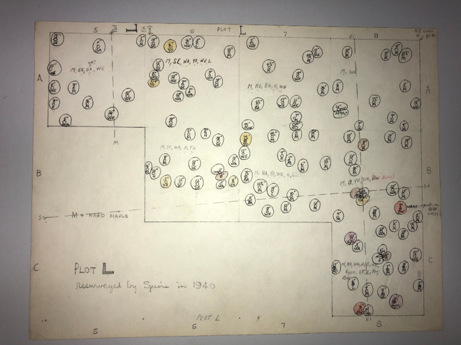
Additional counts of trees in Trelease were made by Boggess in 1963 (following Dutch elm disease in the 1950s), by Pelz and Rolfe in 1977, and periodically by Edgington from 1980-2000. The current census, however, is the first census in which trees have been mapped since Vestal’s 1936 census. Collectively these data allow us to examine how the composition, basal area and above ground biomass has changed over nearly a century, and following two major die-offs associated with Dutch elm disease, and more recently, arrival of the emerald ash borer.
Trelease joins a number of other ForestGEO plots in the American Midwest. Are there specific research questions about this region that you hope to address?
Trelease is different from most other ForestGEO sites because it is a small fragment surrounded by agricultural land. It is therefore representative of much of the fragmented forest cover consisting of isolated woodlots in the intensively farmed portions of the Midwest United States. We are therefore interested in how turnover rates differ in Trelease and comparable ForestGEO plots in the region, as well as how the current die-off of ~600 mature ash trees in Trelease will impact regeneration processes. We also have extensive data over the last three decades on treefalls in Trelease which we have been using to estimate rates of decomposition for dominant tree species. We are now looking at how we can use these data to improve estimates of dead fallen biomass (‘coarse woody debris’), a substantial component of the forest carbon budget.
What is your favorite tree species at Trelease? What makes it stand out?
It’s tempting to say pawpaw (Asimina triloba) because there are 10,250 of them in the forest understory. However, I don’t think anyone was very fond of them by the end of the census! My favorite is the bur oak. We have a few very large individuals (nine with a DBH >1 meter). From coring of recently fallen individuals we know these are >300 years old and up to 500 years old. These are the ‘pre-settlement trees’ that were around long before Europeans arrived in Illinois. They are easy to identify and spot even from the distance in the winter time because of the characteristic architecture of their fine branches.

Roughly 70 undergraduate students contributed to the success of the first census. Will there be opportunities for students to stay involved with the plot now that the first census has been completed?
We are indebted to Prof. Greg Gilbert from the UC Santa Cruz plot who provided a lot of guidance on how to organize and manage a student-led census. The first four months were pretty busy with multiple groups of students going to Trelease seven days a week! We also received financial support for the census from the Student Sustainability Committee (SSC) at the University of Illinois. The SSC manages funds generated from student fees to promote activities that have an environmental impact on our university community. Now that the first census is completed they are continuing to fund student involvement in generating a carbon budget for Trelease.
Trelease has also been used extensively for undergraduate teaching, with more than 200 students visiting the woods every year. An important motivation for establishing the plot was to be able to integrate the use of plot data into undergraduate classes. We just received a grant from the university to produce lesson plans for our ecology classes. These plans will guide students through the process of using the data and generating hypotheses that can be tested by collecting additional data in the forest.

**On Wednesday, May 18th, at 9 AM, EDT Jim Dalling will offer a short talk about Trelease Woods at the ForestGEO Seminar Series. Learn more and register here.